Drainage System of India
TGPRB Constable / SI · 2–3 direct questions per paper. Learn the rivers on the map, then attach the facts - that is exactly how the exam asks them.
How TGPRB tests this topic
Cover all six and you have everything TGPRB has ever asked about drainage here. Anything outside these six is context, not exam material.
Predicted 2026 Question Patterns
Primary Format: Match the Following (River ↔ Tributary / Dam), followed by 4-Statement True/False Verifications on East vs West flowing rivers. Trap alert: TGPRB frequently pairs Krishna tributaries with Godavari to induce negative marking.
The Map
This is your anchor. Rivers are spatial - that is how the exam tests them (tributary order, dam placement, which river ends where). Learn the shape first, then click a river to attach its PYQ-marked facts.
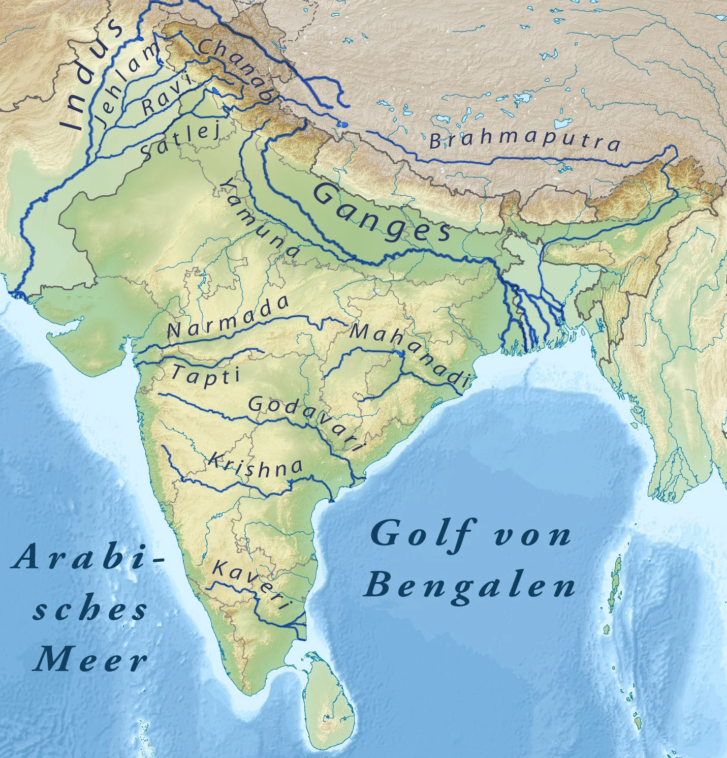
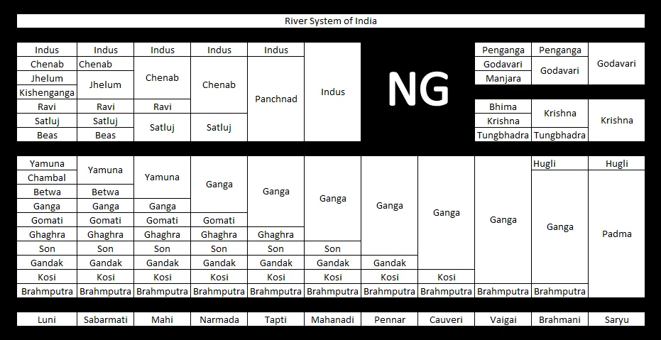
System Layout: Tributaries & Major River Basins (Wikimedia Commons / Public Domain)
Hierarchy at a glance
Indian Drainage System
├── Himalayan Rivers (perennial, glacier-fed)
│   ├── Indus → 5 tributaries (J C R B S, west→east)
│   │   Doabs: Sindh Sagar · Chaj · Rechna · Bari · Bist
│   ├── Ganga  → Largest basin; delta = Sundarban
│   └── Brahmaputra → antecedent · Tsangpo→Dihang→Brahmaputra
└── Peninsular Rivers (seasonal, rain-fed)
    ├── East-flowing (deltas): God > Kri > Maha > Cau
    ├── West-flowing (estuaries): Narmada, Tapi (rift valleys)
└── Inland (no sea): Luni → Rann of KutchIntroduction
A drainage system is the network of rivers, streams, and lakes draining a particular area. India's drainage pattern is shaped by its geological structure, rock type, slope, and climate - making it one of the most diverse on Earth.
Why this topic matters for TGPRB
31 verified PYQs across Constable + SI papers (2015–2023). Expect 2–3 per paper. Top question types follow the coverage strip above: tributaries, dam–river–state, waterfalls, doabs and drainage termination.
Deep Dive
Read each system, then hit map to jump to it on the physical map - see the fact where it happens.
A. Himalayan Rivers perennial · glacier-fed
1 · Indus System
- Origin
- Near Lake Mansarovar, Tibet → Ladakh → Pakistan
- Length
- 2,880 km total · 709 km in India
5 tributaries, east → west - mnemonic S R B C J (see them on the map)
| River | Ancient name | Doab |
|---|---|---|
| Sutlej | Shatudri | Bist (with Beas) |
| Beas | Vipasha | Bari (with Ravi) |
| Ravi | IravatiPYQ | Rechna (with Chenab) |
| Chenab | Asikni | Chaj (with Jhelum) |
| Jhelum | Vitasta | Sindh Sagar (with Indus) |
PYQ alert
"Which river is known as Iravati?" → Ravi [Constable 2015]
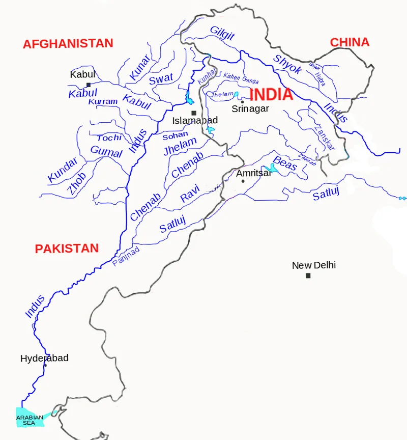
Indus River Basin - Wikimedia Commons / CC BY-SA
2 · Ganga System
- Origin
- Gangotri Glacier (Bhagirathi) → meets Alaknanda at Devprayag
- Length
- 2,525 km · largest basin in India
- Delta
- Sundarban Delta - largest river delta in the world
Left bank
Ramganga · Gomti · Ghaghara · Gandak · Kosi · Mahananda
Right bank
Yamuna · Son · Damodar
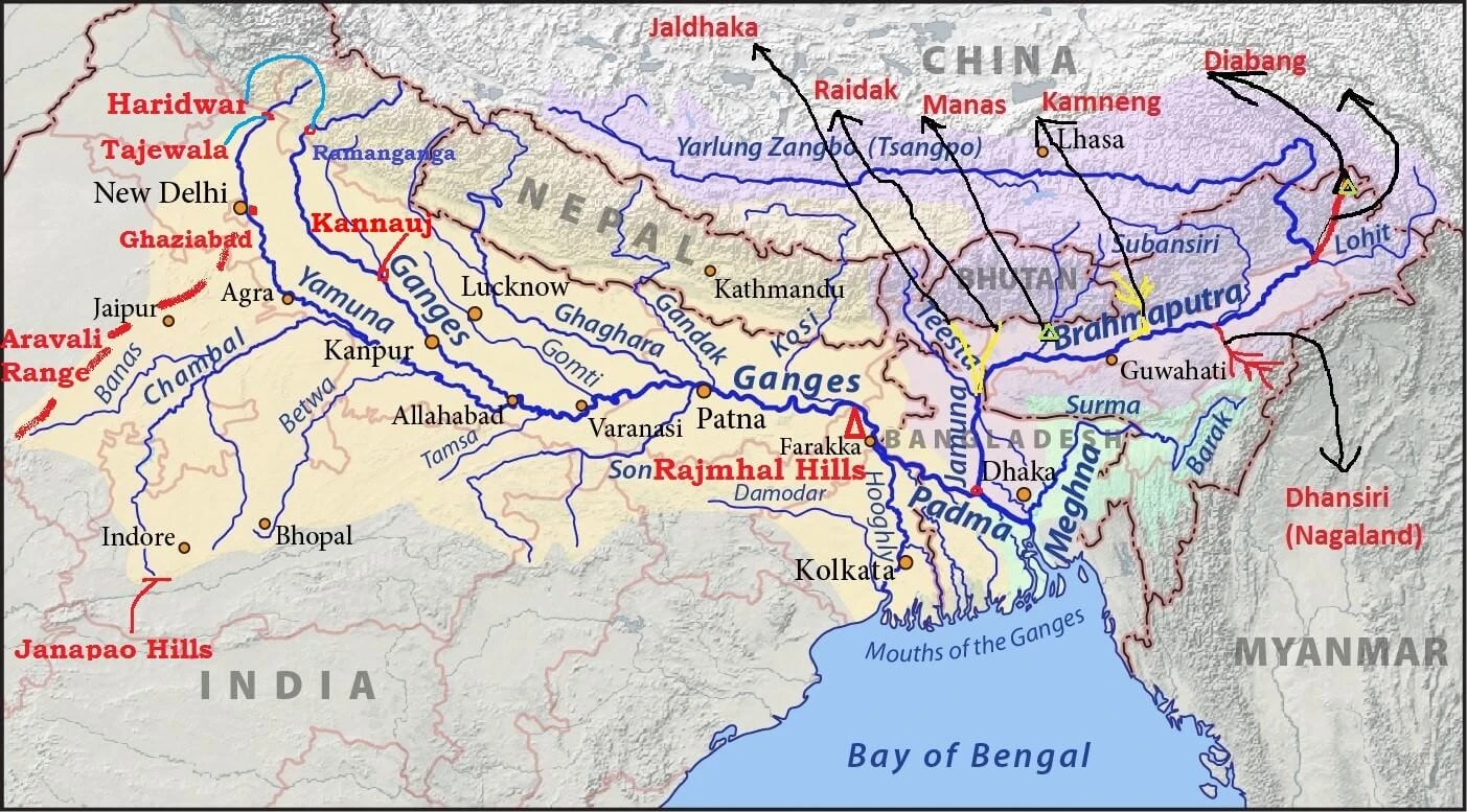
Ganga-Yamuna River System & Tributaries (PMF IAS / Exam Diagram)
3 · Brahmaputra System
- Origin
- Near Lake Mansarovar, Tibet
- Names
- Tsangpo (Tibet) → Dihang (Arunachal) → Brahmaputra (Assam)
- Key fact
- Antecedent river - older than the Himalayas, cuts through them
PYQ alert
"Brahmaputra is antecedent / called Tsangpo in Tibet" - direct assertion PYQ.
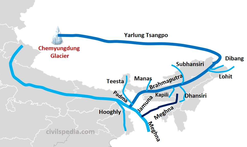
Brahmaputra River System & Tributaries (Civilspedia Exam Diagram)
B. Peninsular East-Flowing Rivers deltas → Bay of Bengal
Mnemonic - by length
God KriMa Cau - Godavari (1,465) → Krishna (1,400) → Mahanadi (858) → Cauvery (800)
| River | Origin | Length | Key tributaries | States |
|---|---|---|---|---|
| Godavari | Nasik, MH | 1,465 km | Pranahita, Indravati, SabariPYQ, Manjira | 7PYQ |
| Krishna | Mahabaleshwar, WG | 1,400 km | Bhima, Tungabhadra, Musi | MH, KA, TS, AP |
| Mahanadi | Sihawa, CG | 858 km | Seonath, Hasdeo | CG, OR |
| Cauvery | Brahmagiri Hills, Coorg | 800 km | Hemavati, Kabini | KA, TN, KL |
PYQ traps on Godavari
Easternmost tributary → Sabari (NOT Indravati) - spot it on the map. States in catchment → 7 (MH, TS, AP, CG, MP, KA, OR).
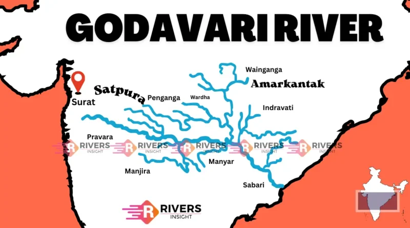
Godavari River Basin (TSLPRB / TGPRB Master Reference Diagram)
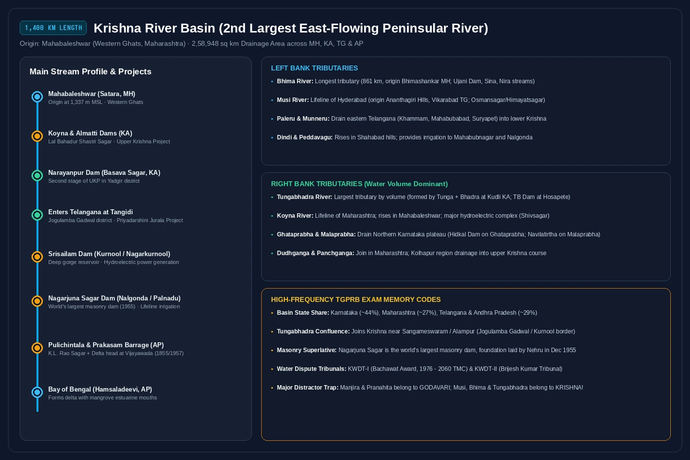
Krishna River Basin (TSLPRB / TGPRB Master Reference Diagram)
Mahanadi River Basin (TSLPRB / TGPRB Master Reference Diagram)
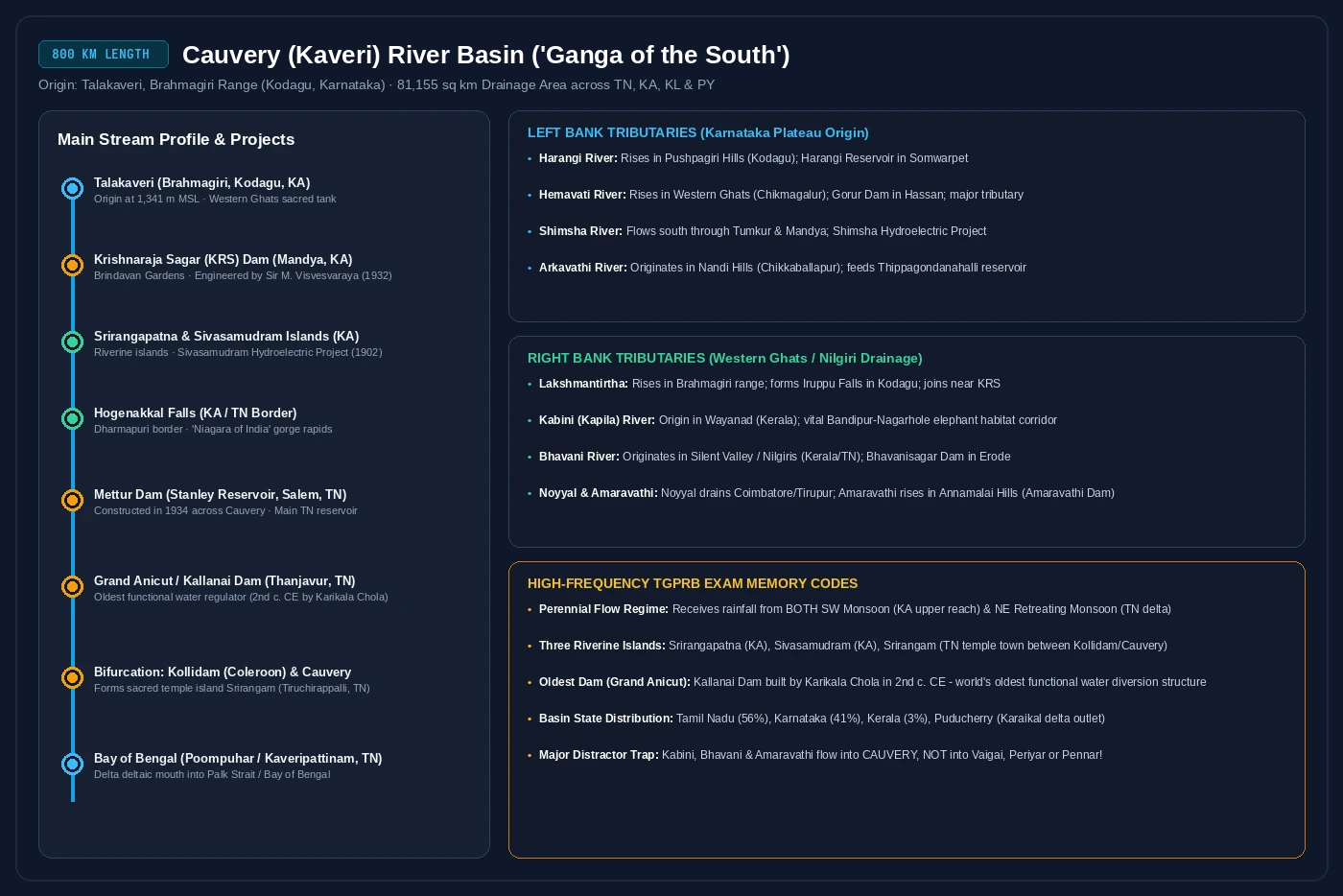
Cauvery / Kaveri River Basin (TSLPRB / TGPRB Master Reference Diagram)
C. West-Flowing Rivers Arabian Sea · rift valleys
Key rule
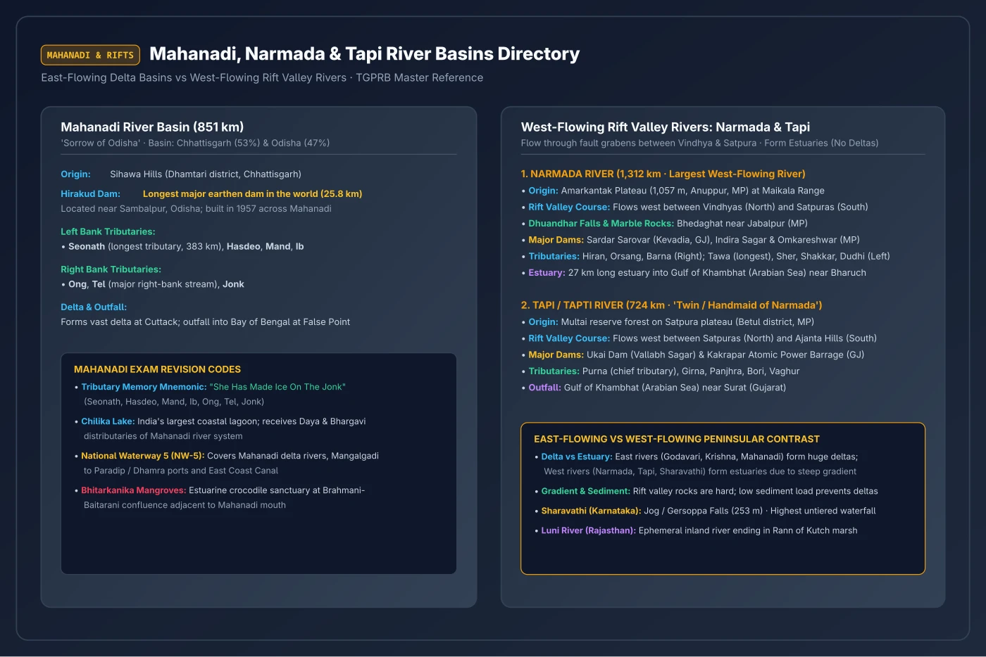
Narmada & Tapi flow through rift valleys - no deltas, they form estuaries instead. The map shows them squeezed between the Vindhya (N) and Satpura (S) ranges.
| River | Origin | Length | Key feature |
|---|---|---|---|
| Narmada | Amarkantak, MP | 1,312 km | Rift valley, Vindhyas (N) & Satpuras (S) - no deltaPYQ |
| Tapi | Multai, Betul, MP | 724 km | Rift valley, parallel to Narmada |
| Sabarmati | Aravalli Hills, RJ | 371 km | Gulf of Khambhat |
| Luni | Pushkar Valley, RJ | 495 km | Rann of Kutch - inland, never reaches the seaPYQ |
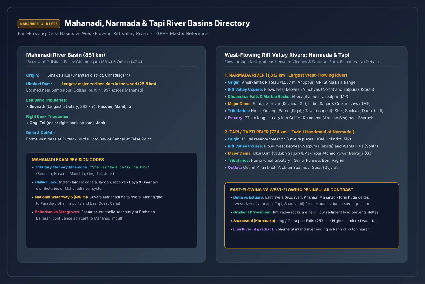
Narmada River System (TSLPRB / TGPRB Master Reference Diagram)
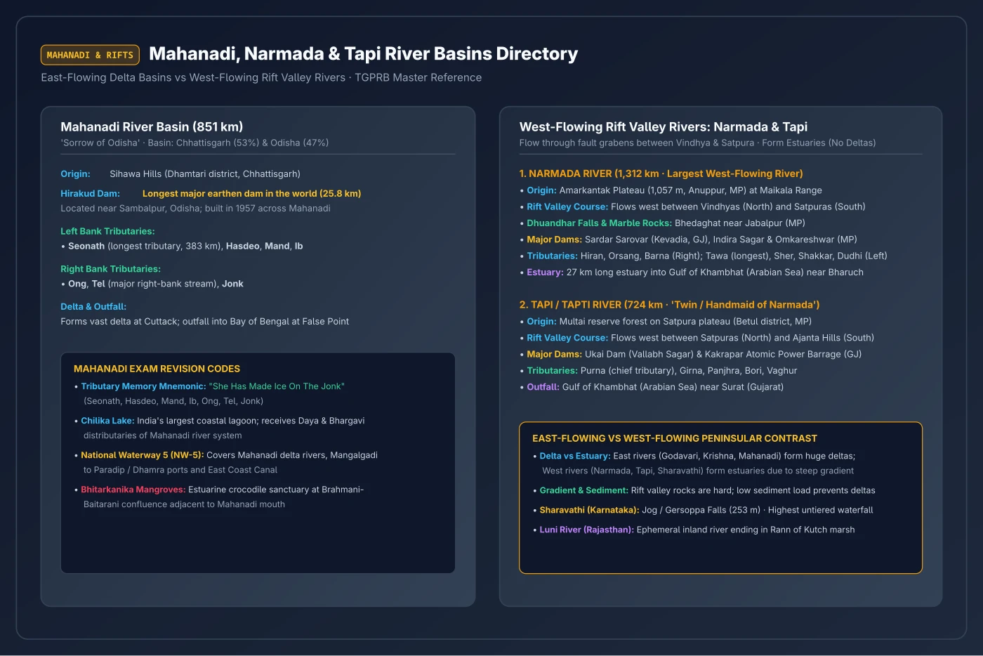
Tapi River System (TSLPRB / TGPRB Master Reference Diagram)
D. Dams & River Projects dam–river–state matching
| Dam / Project | River | State |
|---|---|---|
| Bhakra-Nangal | Sutlej | HP / Punjab |
| Sardar Sarovar | Narmada | Gujarat |
| Ukai PYQ | Tapi | Gujarat |
| Matatilla PYQ | Betwa | Uttar Pradesh |
| Hirakud | Mahanadi | Odisha |
| Tehri | Bhagirathi | Uttarakhand |
| Salal PYQ | Chenab | J&K |
| Sriram Sagar TS | Godavari | Telangana (Nizamabad) |
| Kaleshwaram TS | Godavari | Telangana |
| Lower Manair TS | Manair | Telangana (Karimnagar) |
| Kadam TS | Kadam | Telangana (Adilabad) |
| Jayakwadi | Godavari | Maharashtra |
PYQ trap - Salal Project
Salal → Chenab. The 2018 Prelims tested the Salal–Tapi pair as the WRONG option - see Salal in the far north on the map, nowhere near Tapi.
E. Waterfalls & Rivers
| Waterfall | River | Note |
|---|---|---|
| Jog (Gersoppa) | Sharavathi | Highest in India |
| Dhuandhar PYQ | Narmada | Also: Marble Falls |
| Kapildhara | Narmada | Near Amarkantak origin |
| Dudhsagar | Mandovi | Goa |
| Hogenakal | Cauvery | Tamil Nadu |
Data & Comparisons
Major rivers - quick reference
| River | Origin | Length | Drains into | Key fact |
|---|---|---|---|---|
| Ganga | Gangotri Glacier | 2,525 km | Bay of Bengal | Largest basin in India |
| Brahmaputra | Tibet (Mansarovar) | 2,900 km | Bay of Bengal | Antecedent · Tsangpo |
| Godavari | Nasik, MH | 1,465 km | Bay of Bengal | "Dakshin Ganga" · 7 states |
| Krishna | Mahabaleshwar | 1,400 km | Bay of Bengal | 2nd largest peninsular |
| Narmada | Amarkantak | 1,312 km | Arabian Sea | Rift valley · no delta |
| Tapi | Multai, Betul | 724 km | Arabian Sea | Parallel to Narmada |
| Cauvery | Brahmagiri Hills | 800 km | Bay of Bengal | Sacred river of South |
| Mahanadi | Sihawa, CG | 858 km | Bay of Bengal | Hirakud Dam |
| Luni | Pushkar Valley, RJ | 495 km | Rann of Kutch | Inland drainage only |
Doab reference
SI Prelims favourite| Doab | Between rivers |
|---|---|
| Bist | Beas - Sutlej |
| Bari | Beas - Ravi |
| Rechna | Ravi - Chenab |
| Chaj | Chenab - Jhelum |
| Sindh Sagar | Jhelum - Indus |
Mnemonic BiBarReChaJ → Bist, Bari, Rechna, Chaj, Jech - east to west
Memory Hacks
Mnemonics exist only for the parts the map can't carry - mostly east-to-west ordering. Spatial facts live on the map; these are the residual sequences.
Peninsular east-flowing rivers - by length
God KriMa Cau
Godavari (1,465 km) → Krishna (1,400 km) → Mahanadi (858 km) → Cauvery (800 km)
Indus tributaries - west to east
J C R B S
Jhelum · Chenab · Ravi · Beas · Sutlej
Doabs - east to west
BiBarReChaJ
Bist · Bari · Rechna · Chaj · Jech (Sindh Sagar)
Brahmaputra names across regions
T → D → B
Tsangpo (Tibet) → Dihang (Arunachal) → Brahmaputra (Assam)
The Tilted Table
Think of India like a tilted table: the Western Ghats are the high edge on the west. Pour water - most flows east to the Bay of Bengal. Narmada and Tapi found cracks in the table (rift valleys) and escaped westward. Rebel Luni just gives up halfway - on the map it is the dashed river that fades into the Rann of Kutch.
PYQs
Real TGPRB Verified Questions (2015–2023)
Filter by exam type (Constable / SI), paper year, or specific river system. Click options to test your knowledge!
Matatilla Project was built on which of the following rivers?
Which of the following river/s is/are not a tributary of the river Krishna? (a) Panchganga (b) Malaprabha (c) Purna (d) Pravara
Which of the following is the easternmost tributary of the Godavari river system?
Which one of the following pairs related to hydro-electricity projects and rivers is not correct?
Consider the following rivers in India from North to South and identify the correct sequence: a. Mahi, b. Sabarmati, c. Tapi, d. Luni
'Marble Water Falls' (Dhuandhar Falls) is connected with which river ?
The number of states at present which fall in the catchment area of Godavari river
The Luni river, which originates in the pushkar valley of the Aravalli range, ends in which among the following?
Ukai dam is situated across which of the following rivers?
Match the following: List - I (a) Guru Shikhar Peak (b) Dhuadhar waterfall (c) Thalghat gap (d) Coral reefs List - II (i) Lakshadweep islands (ii) Western ghats (iii) Narmada river (iv) Aravallis
Match the following List - I a) Sardar Sarovar dam b) Highest mountain peak in South India c) Todas d) Copper List - II i) Anaimudi ii) Agnigundala iii) Narmada iv) Nilgiri
Match the following List - I River a) Ganga b) Brahmaputra c) Godavari d) Krishna List - II Tributary i) Bhima ii) Wainganga iii) Teesta iv) Kosi
Match the following List - I Waterfall a) Dudhsagar b) Kapildhara c) Hogenakal d) Jog List - II River i) Mandovi ii) Narmada iii) Cauvery iv) Sharavaty
Match the following List - I River a) Cauvery b) Narmada c) Sabarmati d) Krishna List - II Source/origin i) Brahmagiri Hills ii) Amarkantak Plateau iii) Aravalli Hills iv) Western ghats
Match the following List - I Project a) Rihind b) Sileru c) Mettur d) Almatti List - II State i) Karnataka ii) Tamilnadu iii) Andhra Pradesh iv) Uttar Pradesh
Read the following statements a) River Brahmaputra is an antecedent river. b) In Tibet, it is called as Tsangpo. c) The important tributaries are Shyok, Shigar. Which of the above statements is/are correct
The Coast Line of India excluding Islands is approximately:
Bhakra-Nangal project is constructed on the river
Match the following List - I Project a) Rihind b) Sileru c) Mettur d) Almatti List - II State i) Karnataka ii) Tamilnadu iii) Andhra Pradesh iv) Uttar Pradesh The correct answer is
Assertion (A): West flowing rivers of peninsular India have no deltas. Reason (R) : These rivers do not carry any alluvial sediments. Correct answer is :
Assertion (A): West flowing rivers of peninsular India have no deltas. Reason (R) : These rivers do not carry any alluvial sediments.
In June 2018 Kerala initiated 'Water Literacy' campaign to create awareness about the importance of water conservation in the state. What are the correct statements from the following? (A) 70,000 students are involved. (B) Every student will campaign for 15 families. (C) Approximately 10 lakh people will be benefited knowing the importance of water, prevention of water pollution. (D) It is mandatory in Kerala. Choose the correct answer:
Consider the following rivers in India from North to South and identify the correct sequence : a. Mahi b. Sabarmati c. Tapi d. Luni
The lake Vembanad is located in:
Assertion (A): Delta formation is not seen along the western coastal plains of India. Reason (R): Indian western coastal plains are more broader than the eastern coastal plains. Choose the correct answer:
Match the following: List - I (Doab) (a) Bist (b) Bari (c) Chuj (d) Rechana List - II (Rivers) (i) Ravi and Chenab (ii) Chenab and Jhelum (iii) Beas and Ravi (iv) Beas and Sutlej Choose the correct answer/pairs:
Read the following statements: (a) River Narmada flows in a rift valley. (b) Vindhya mountains are located to the south of river Narmada. (c) River Narmada is a west flowing river. Which of the statements are correct?
China is reportedly building a new dam on Mabja Zangbo river in Tibet at the trijunction with India and Nepal, the other side of the state _____
Which of the following River is also known as 'Iravati'?
Srinagar is situated on the bank of which river?
When was the Godavari Water Disputes Tribunal headed by Justice Bachawat constituted by the central Government of India?
Advanced Practice
TGPSC-Style Advanced Practice
These questions use multi-statement, matching, and assertion-reason formats from the TGPSC Group-I 2024 paper. TGPRB papers (2022-2023) remain 92-93.5% direct factual MCQs. These drills harden your fact base against a potentially harder 2026 format.
Source: Forensic Paper-Setting Evolution Audit, Aug 2026 - 1,350 questions classified across 7 papers.
Match the following lift irrigation projects/barrage with the rivers: A. Mahatma Gandhi Kalwakurthy Lift Irrigation Project B. Nizam Sagar Project C. J. Chokka Rao Devadula Lift Irrigation Scheme D. Chanaka-Korata Barrage I. Godavari II. Krishna III. Penganga IV. Manjeera
Consider the following statements: A. Koulasnala and Boggulavagu irrigation projects are located in the Godavari basin. B. Kotepally Vagu and Asif Nahar irrigation projects are located in the Krishna basin. Which of the above statements is/are correct?
Which of the following fluvial landforms are associated with rejuvenated topography? A. Incised meander B. Entrenched meander C. Knickpoint D. Natural levees Choose the correct answer:
Consider the following statements about the Godavari river system: A. It is the longest peninsular river of India at 1,465 km. B. Its basin covers parts of 7 states. C. It originates near Trimbakeshwar in Maharashtra. D. It drains into the Arabian Sea. Which of the above statements are correct?
Match the following rivers with their place of origin: A. Narmada B. Krishna C. Cauvery D. Godavari I. Brahmagiri Hills II. Trimbakeshwar III. Amarkantak IV. Mahabaleshwar
Comprehension Gate
Current Affairs
Current Affairs (1/127)
Union Environment Minister releases two male Great Indian Bustards into the wild at Desert National Park, Jaisalmer
Two male Great Indian Bustards were released into the wild at Sam in the Desert National Park, Jaisalmer, Rajasthan by Union Minister Shri Bhupender Yadav.
Union Minister for Environment, Forest and Climate Change Shri Bhupender Yadav released two male critically endangered Great Indian Bustards (GIBs) into the wild at the Desert National Park in Jaisalmer, Rajasthan. The Bustard Recovery Programme is a collaborative initiative involving the Ministry, Rajasthan Forest Department, and the Wildlife Institute of India.